Friday, November 26, 2010

Two days in Bay of Bengal


Brief note about Pondy

The Union Territory of puducherry comprises of four coastal regions viz- puducherry, Karaikal, Mahe and Yanam. puducherry and Karaikal are situated on the East Coasts in Tamil Nadu, Yanam in Andra Pradesh and Mahe on the West Coast in Kerala.
puducherry is the Capital of this Union Territory. It is on the east coast about 162 kms south of Chennai (Madras) located on the Coromandel Coast of the Bay of Bengal. There are no hills or forests in this region. The main soil types in this region are red ferrallitic, black clay and coastal alluvial.

Main languages spoken in the region are Tamil, Telugu and Malayalam. English and French are other languages, which are spoken by a considerable number of people. Majorities of the people are Hindus. There are quite a number of Christians and Muslims, whereas very few Jains, Sikhs and Buddhists.
puducherry is a unique place. Many feel that it has a distinct spiritual vibration. Stories of resident sages come down through its history from the earliest days. The nickname “Pondy” sums up this shared feeling of belonging, of having come home.
puducherry is best accessible by road from Chennai, Bangalore and even from Kerala.Chennai has an international airport which directly connects to the highway to puducherry. And good transit hotels are available in the vicinity for travelers who arrive in the night.

We left to Pondy on Friday night by train and reached there on Saturday morning at 10:00am. Once we reached our hotel we had nice breakfast and started to explore the place. We hired activa on first day. There are not much places to visit but I feel food is awesome. We had a delicious food for two days. We could relish the cheese garlic bread,french fries at rendezvous and a mug of beer. One should try out the varieties of dosas we get there,really worth trying. There are lot of Italian restaurants but hardly get Italian foods. We were in search of Italian ice creams but we couldn't find one. One can go to Mahabalipuiram from Pondy if you have private vehicle, its 90kms away from Pondy.
We stayed in hotel Jayaram.

Places to visit

Auroville
Aravinda ashram
Beaches
Paradise Island
Churches
Cafe corners

How to reach

Can go by private vehicle or by train/bus. Can hire vehicle over there

Total distance

Nearly 450kms from Bangalore

Sunday, October 24, 2010

Somanathapura and Shivanasamudra


This trip happened all of sudden. On Saturday night when I saw Navs online,I just pinged him and asked whether he is free on Sunday,he said yes. Then I asked him what if we could plan for Somanathapur which was long pending spot to visit. He agreed. So we decided too leave 6:00 in the morning. So we started around 6:15am from our room and headed to Mandya. It was breezing heavily in the NICE road. We stopped in Mysore highway near to Maddur in Adigas for breakfast and had Open butter masala dosa :). We took the divertion near to Maddur to go to Shivanasamudra since Navs haven't seen that place earlier. So got to see Bharachukki and gaganachukki falls once again. Later came back till Malavalli and took the divertion and headed towards Bannur. When we reached Somanathapura it was 9:30am

History

Somanathapura ಸೋಮನಾಥಪುರ (also known as Somnathpur) is a town located 35 km from Mysore city in Mysore district, Karnataka, India. Somanathapura is famous for the Chennakesava Temple (also called Kesava or Keshava temple) built by Soma, a dandanayaka (commander) in 1268 CE under Hoysala king Narasimha III, when the Hoysalas were the major power in South India. The Keshava temple is one of the finest examples of Hoysala architecture and is in a very well preserved condition. The temple is in the care of the Archeological Survey of India as a protected heritage site.

The reigning monarch was Narasimha III (1254-91 A.D.) whose full regal title runs into a sizeable paragraph: "Sri Vishnuvaradhana, Pratapa Chakravarti, Hoysala Bhujabala, Sri Vira Narasimha, Maharajadhiraja, Raja Paramesvara, Sanivarasiddhi, Giridurgamalla etc.

The temple, however, was built by the celebrated army commander, Somnath. Some years earlier he had founded a village on the left bank of the Kaveri River, which he had named Somnathpur, after himself.

The temples in Somnathpur are not as widely known as the ones in Belur and Halebid, though they all are from the same period. Somnathpur is more representative of the age, since it did not suffer destruction as much as Belur and Halebid did and hence offers a better view of the period's architecture. Often it is referred to as the poor cousin of Belur and Halebid. Somnathpur's temples adhere to the typical Hoysala style of architecture, where the temple is designed as a mini cosmos with scenes carved on the walls including Gods, Goddesses, dancing girls, musicians, gurus and all kinds of animals including elephants, lions, cows and monkeys.

Its unique design and perfect symmetry are ignored amidst the farms and agricultural lands of surrounding villages. It is visited more by foreign tourists than domestic.

At the temple, the outer walls are decorated with a series of star-shaped folds and the entire surface is covered with carved stone plaques. The walls above the plinth are also carved with exquisite figures of gods and goddesses, taken from the Hindu puranas, and meticulously arranged in vertical panels.

The most widely known temple is the one dedicated to Keshava, built around 1268 AD by which time the Hoysalas had completed 260 years in power. However, the temples of Somnathpur were not built by the king, but by popular army commander Somnath. He founded a village on the banks of the Cauvery and then embarked on constructing temples in a bid to further his immortality.

The temple itself, stellar in shape, has three profusely carved pinnacles with a common Navranga and stands on a raised platform.

The three sanctum sanctorums once housed beautifully carved idols of Kesava, Janardhana and Venugopala. Today, the idol of Lord Kesava is missing but the other two still adorn the sanctum sanctorums in their original form.

How to reach
1.Bangalore-Ramanagara-Channapatna-Maddur-Malavalli-Bannur-Somanathapura.
2.Bangalore-Kanakapura-Malavalli-Somanathapura.

Total Distance
150kmx2

Sunday, August 22, 2010

Two days in Sakleshpur


Its been pretty long time since we been for a long ride by bike. So we decided to go to Sakleshpur. Actually we wanted to ride our bikes when its raining. So Sakleshpur is came into our mind. Rather than the place, we were enthusiastic to drove our bike for a long. So we started our journey on 14th August Saturday around 7.00am from Bangalore. Our teammates already reserved the stay at the place called Jenukallu resort. We reached our destination at around 12.00 noon. It was nice journey,when we reached Sakleshpur it started drizzling and when we moved further it was started pouring heavily. So we were dripping wet when we reach the place. Roads were very bad and slippery so one of our teammate fell down.The best thing I wanted to mention over here is the coffee we had on our way. We stopped our bike in one point to stretch for a while and we had coffee in one small canteen. The coffee was ultimate,even we don't get such taste in any of the coffee day for sure.

The place
Sakleshapur or Sakaleshpura the town with the bountiful is located on the border of Malnad and Bayaluseemae in Hassan district of Karnataka, South India. It is located at an average elevation of 949 metres (3113 feet). Since it has temperate climate on the Western Ghats, it is suited for growing Cash crops. Coffee growers from the neighboring villages throng to sell coffee at Sakleshpur. The town lies on National Highway 48 (NH-48), which connects Mangalore with Bangalore.

History
Long ago a Shiva Linga which is broken/ cracked was found in these regions. Hence Sakala means Bhirukada or Bhinnavada meaning " broken " or "cracked" . There is a Shiva temple at the entrance of the town. It is also means Sakal Aaishwarya Pura meaning Town with all Wealth, river, coffee, cardamom, pepper, hill stations education etc. Sakaleshwara swami rata yatra or Car Festival takes place every year in February.

Our destination is Jenukallu
The western ghats is a trekkers paradise. A trek to JENUKALLU mountain, which is the second highest peak in Karnataka will be the most memorable experience.

From the top of Jenukallu Mountain on a clear day, one can see the coast of Arabian Sea in Mangalore. Needless to say, you will be on top of the world after climbing the peak of JENUKALLU. If you are not interested in long distance treks, then the mountain which stands right next to the resort is the place for you. You can watch the beautiful sunset and sunrise and of course the mesmerizing landscape of western ghats.

JenuKallu Valley Retreat is located in near Devaldkere village, 265 kms away from Bangalore, 27 kms from Sakleshpur in the Western Ghats. Our resort is strategically located on the hill ranges of JenuKallu and serves as a wonderful way to experience Nature. Sakleshpur is located in the Western Ghats, a mountain range that stretches from Kerala to Gujarat. The southern range, which includes Bisle reserve forest and the region around Sakleshpur is listed as one of the 18 most diverse spots in the world in terms of flora and fauna. The sub-tropical climate and heavy rains during the wet season create an environment where several unique plant and animal species flourish.
Marked by its tranquility and verdant greenery, Sakleshpur lies in the southern section of extensive mountain range of the Western Ghats. One such mountain range is the JenuKallu mountain which is the second highest peak in Karnataka only next to Mullayanagiri.

Trekking
First day we decided to climb a small hill to get a full view of the place. It looked like a simple task of walking on the ridge from one peak to another!! We could see lot of leaches on the way to hill. I got a bite for sure. I was not realized it first,when I got to see the blood clot on my feet. From the top of Jenukallu Mountain on a clear day, one can see the coast of Arabian Sea in Mangalore. Needless to say, you will be on top of the world after climbing the peak of JENUKALLU. If you are not interested in long distance treks, then the mountain which stands right next to the resort is the place for you. You can watch the beautiful sunset and sunrise and of course the mesmerizing landscape of western ghats.
In the night they have arranged a campfire for us and we had a fun till late night and slept lateron.

Temple visit
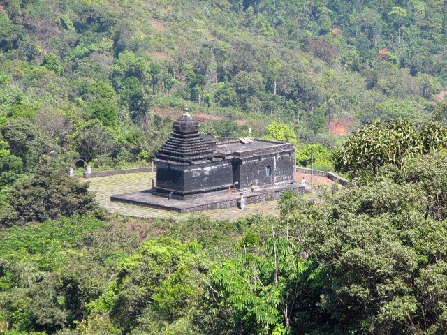
On the second day we decided to visit the temple and falls.So our vehicles headed towards the temple. The day was 64th Independence day. We got to see the flag hoist in one small school when we were passing. We visited Betta Byraveshwara Temple which was near to our resort. This Temple is in a serene location on a hill top. It looks like the road is constructed newly to the Temple. I was astonished upon seeing a brand new sulabh sauchalaya (Toilet) next to the Temple!! It was too much for a Temple located in a remote location. But anyway, the Temple is quite old and provides some nice view of the surrounding places.We then climbed a small hill to get a full view of the place. The Jenukallu gudda and digallu peak were the prominent ones.We spent some time just watching those peaks and lazed at a small pond next to the Temple. Later we went to see the Devaladakere falls. Some of us had nice bath over there. We were there for few mins then came back to our place and packed our bags and started back. Again we got the rain when we started from there.


How to reach

Bangalore-->Tumkur road-->Nelamangala road-->NH48-->Kunigal-->CR Patna-->Hassan-->Sakleshpur-->Take right turn at Anemahal-->Hanbal-->Devaladakere-->Athibeedu-->Jenukallu valley retreat

Total distance

265kms from Bangalore
From Sakleshpur to resort 27kms

Sunday, December 20, 2009

One day visit to golden temple

Ops.. we had planned to go for outing after a long time..after a year. Anyways it was decided to go to Rangasthala and ghati subramanya but last minute plan got changed and all decided to go Vellore golden temple. Even I heard about it and seen some mails about the place,so interested me to visit once. So we left B'lore at 7:30am on Saturday. This time we went by car. Its 250km away from B'lore.Road was good but have to pay for toll in 3 places.

About Vellore:
==========

Golden Temple - when uttered this word, immediately people thinks of Amritsar and the Highest Body of the Sikh's pride Golden Temple. But now it has got a good competition! Yes, an estimated over 600 Crores of Indian Rupees spent, to construct a true Golden Temple for Goddess Mahalakshmi, the presiding deity, (installed and maintained by Sri Narayani Peedam) in this Temple at Sripuram, which is situated 6 km away from the District Headquarters - Vellore, North Arcot District in Tamilnadu. Now, the temple is complete, open to the general public; this town Sripuram has all the facilities one can visit to enjoy his/her spiritual experience.

A Mahalakshmi temple called 'Sripuram' and made of more than a ton of pure gold will glitter and gleam under the sun on August 24 when it is unveiled for consecration by the Sri Narayani Peetam headed by a 31-year-old godman who calls himself Narayani Amma. Devotees hail the temple as 'one of the wonders of the world' and say that it is the only temple covered fully with gold.

More than 400 gold and coppersmiths from the Tirupathi Thirumala Devasthanam are said to have worked for six years to craft the Rs. 600-crore golden temple located on 55,000 sq ft of land on a 100-acre salubrious stretch in Malaikodi, about 6 km from Vellore in north Tamil Nadu. According to official sources, the gold bars were purchased through RBI in "a transparent manner "

First the coppersmiths set to work creating a copper base on the temple structure with engravings and etchings before the gold, beaten into nine layers of foils, was draped around it. The sanctum sanctorum will hold the deity of Mahalakshmi made of stone granite, but covered with gold protection layers. (Kavacham - adornments).

While coming back we visited Vellore fort. It was huge fort.

Vellore Fort is a large 16th-century fort situated in Vellore city near Chennai, in the state of Tamil Nadu, India. It was built by the Nayakar governors of the Vijayanagara Empire and was constructed with large granite blocks. The fort is known for its grand ramparts, wide moat and robust masonry.

The Fort's ownership passed from the Nayaks, to the Bijapur Sultans, to Marathas, to the Carnatic Nawabs and finally to the British, who held the fort until India gained independence. During British rule, the Tippu Sultan's family and the last king of Sri Lanka, Sri Vikrama Rajasinha were held in as royal prisoners in the fort. The fort houses a Christian church, a Muslim mosque and a Hindu temple, the latter of which is famous for its magnificent carvings. The first rebellion against British rule erupted at this fort in 1806, and it is also a witness to the tragic massacre of the Vijayanagara royal family of Emperor Sriranga Raya.

While on the way back we visited Yalagiri hills.


How to reach:

Bangalore - Vellore (via Hosur) - 220 kms (On national highway routes - NH7 > via - Hosur Road - Electronic City - Attibele(NH7) - Hosur - Kamandoddi - Shoolagiri- Melumalai - Kurubarapalli - Krishnagiri > NH46> - Bargur - Vaniyambadi - Ambur - Pallikondaj - Vellore. - around 4 hours drive)

Monday, September 21, 2009

One day picnic to Mekedatu and Chunchi falls


We have planned to visit Mekedatu and Chunchi falls on this weekend. So planned to start early morning at 5:00am,but unfortunately it started drizzling at 4:30. So had to wait for 30mins more to rain to stop. So we all gathered at METRO, kanakapura road. We 7 on four bikes headed towards Kanakapura...We decided to go to Chunchi falls first.The falls is settled 90 km away from Bangalore city. It is 16 km before the Sangama and is located in the Kanakapura taluk. The waterfall is about 6km away from the deviation. The waterfall is nestled among the amazing ranges of rocks on the banks of the River Arkavati. It is located on the way to Yelehalli from Sangam. One can reach to Chunchi falls from Kanakapura. The waterfall is in the backdrop of scenic settings and it offers eye catching panoramic views of the surroundings. It is surrounded by dense and green forests. The falls is a popular picnic spots. Even though it is a small waterfall, the beauty of its rushing cascades of water in a green setting enchants tourists.

Mekedatu
========
Mekedatu means Goat's Leap in Kannada. ‘Mekedatu’ is the place where the Kaveri (Cauvery) River flows through a narrow ravine. Legend has it that the channel was so narrow that sheep would jump across, and hence the name Mekedatu (Meke = sheep/goat, datu = cross in Kannada) Here the Cauvery river jumps in to deep narrow gorge over which even a goat can leap. One can drive only up to Cauvery Akravati Sangama. After this you can cross the river in coracle ( circular boats ) or by walking if the water level is low. From here Mekedatu is 4km downstream. There is two buses available at the other end which can take you till Mekedatu, but the buses are in horrible condition. We had to pay 40Rs each for round trip. The journey was jumpy ;) The rocks at Mekedatu get slippery during monsoon. Once we back from Mekedatu we decided to go to Shivanasamudra and Talakadu but we couldn't make it Shivanasamudra. When we reached Talakadu it was almost 6:00pm so few of our mates took bath in river and we had chicken and fish and started back to B'lore.

Mekedatu is about 93Kms from Bangalore. The first 89Kms till Sangam can be undertaken in a vehicle, but for the last 4Kms we need to cross a river and either take a different transport bus or
go walking.


How to reach
B'lore-->Kanakapura-->Sangama

Distance
90kms to Chunchi falls

Saturday, February 21, 2009

Family picnic to Belur and Halebidu

Few words about Belur

Belur is a small town in the Hasan district of Karnataka. Here, kings of the Hoysala dynasty constructed the 'Chennakeshava' (handsome Vishnu) temple. It is about one hundred feet high and has a magnificent gateway tower (gopuram), built in Dravidian style. The main temple, surrounded by a group of subsidiary shrines, stands in the center of a rectangular, paved courtyard along the perimeter of which are ranges of cells fronted by a pillared veranda. The temple has lost its super structure but looks very imposing. It has a pillared hypostyle hall (navaranga), a square vestibule (antale ), and a solid, stellate vimana. Three entrances lead into the hall, each being flanked by a shrine. The doorways are guarded on either side by the gorgeously decorated doorkeepers called Jaya and Vijaya. The extensive hall is supported by forty-six pillars, each of a different design. There is one monolithic pillar can be seen near to navaranga.None of the pillars or carvings are similar thou it looks so, when we observed closely there will be slight changes in each design.The symbol of Hoysalas is a man killing a tiger.

Symbol of Hoysala dynasty

The temple was built using the soft soapstone with very intricate carvings.The temple looks like a casket and its 178 feet long(east-west wise)and 156 feet broad(north west wise)
The unique pillars were manufactured by rough-finishing a monolithic block of stone and then mounting it in upright position on a wheel. This was rotated against a chisel, set as a turning tool. Each pillar has a bell-shaped member towards the lower half of the shaft. A sloping bracket has been fixed to the capital by means of sockets. The brackets were carved from single slabs into images, enshrined with leafy aureoles of beautiful maidens known as 'shilabalakis'. The seductive, voluptuary emphasis is remarkable. The subjects are all secular and mostly represented are voluptuous maidens. All are graceful, charming and fascinatingly chiseled out. Each damsel is celestial, with exuberant serene beauty, exhibiting the virtuosity of the sculptors. They all are in conformity with the art of dance and sculpture ( 'Natya' and 'Shilpa' shastras). Hence, their breasts remind of the moon, the waist resembles that of a swan, and their hips remind those of an elephant.

Bittiga, the fourth and mightiest monarch of the Hoysala dynasty, was converted from the Jain faith to the Vaishnava faith by the sage Ramanuja. The king changed his name to Vishnuvardhana and built temples with great vigor and dedication. In order to commemorate his victory over the Cholas in the battle of Talkad, he built Belur Temple in 1117 A.D. and it took 103 years to complete and Vishnuvardhana's grandson Veera Ballala II completed the task.The intricate workmanship includes elephants, lions, horses, episodes from the Indian mythological epics, and sensuous dancers (Shilabalikas).The inside is even more richly carved on its panels and pillers. There is not a portion of the structure that has been left uncarved.The architecture is extremly complex, yet regard for proportion is well maintained. If you insert a thread into the pupil of an eye on one of the sculptures, it would emerge through the nose. suspend a taut string from the forehead of a dancer and it will fall straight to an uplifted toe. The queen Shantala, though a Jain by faith, was noted for catholicity of her religious outlooks. She was a well-known dancer and on one of the temple's brackets her dancing pose has been sculptured in the most ornate and in exuberant style.

The single pillar which stood outside the temple is a monolithic stone and surprising thing is only its three edges are touching the ground and we can pass the paper or kerchief under the pillar. It stood in gravitational force. Hats off to the technological idea which they had so long back.Such technology we can see in Hampi temple as well.

In the rich marble screens of the navaranga there are twenty-eight grill windows. Some are pierced with the conventional patterns. They are generally star-shaped, with bands of foliage, and with figures and mythological subjects. On one of the screens king Vishnuvardhana is shown beside his queen Shantala. A metallic icon of the period depicts the king in a standing posture which gives the exact idea about his stature, personality, dress and different ornaments he wore.

Historians find a tradition that the ancient and medieval Indian artists rarely sign their work of art. However, the Hoysala sculptors have broken this custom and signed their sculptures. They engraved their names, titles and even the place of their origin at the foot of their art work. The stone inscriptions and copper plates of the period give some more details about these artisans. Mallitamma was the most prolific of all known Hoysala artists and more than forty well-executed sculptures stand in his name. Dasoja and his son chavana(though legends assign it to one Jakanachari) were migrants of a nearby town called Ballegavi. Javana is credited for the sculptures of five madanakai damsels and his father is credited for another four. Malliyanna and Nagoja have included birds and animals in their sculptures. The sculptures located in the navaranga were carved out by Chikkahampa and Malloja. It is a great pity that no biographical details about these artisans are available. What these sculptures brought them in return to their hard and extremely pain-taking work must have been a pittance! However, even after a lapse of eight centuries, the art lovers of the whole world can adore them.

The temple occupied nearly 4 acres of land and there are other temples like Kappechennigaraya,Vijayanarayana,Saumyanayaki,Andal etc.

Halebidu

One of the rich carvings in Halebidu

Halebidu (which was previously called Dorasamudra or Dwarasamudra) was the regal capital of the Hoysala Empire in the 12th century. It is home to one of the best examples of Hoysala architecture in the ornate Hoysaleswara and Kedareshwara temples.
The Hoysaleswara temple was built during this time by Ketamala(Kethumalla) and attributed to Vishnuvardhana,Kethumalla was king's chief minister.He showed his loyalty to his king by builting the temple and worshiped as God.Then it was sacked by the armies of Malik Kafur in the early 14th century, after which it fell into a state of disrepair and neglect.Even while british govt. was in rule in India took all the shilabalika's whichever was in good condition(un destroyed by muslims). One can see the places in each nook blank.
The temple complex comprises two Hindu temples, the Hoysaleshawara and Kedareshwara temples and two Jain basadi. In front of these temples there is a big lake. The town gets its name the from the lake, Dhwara samudhra which means entrance from ocean. The two nandi bull statues which are on the side of the Hoysaleshwara temple are monolithic. soap stone or Chloritic Schist was used for the construction of these temples. However a number of sculptures in the temple are destructed by invaders. So the temple is incomplete. Halebid means ruined city. There is an archeological museum in the temple complex.

The Hoysaleswara temple, dating back to the 1121 C.E., is astounding for its wealth of sculptural details. The walls of the temple are covered with an endless variety of depictions from Hindu mythology, animals, birds and Shilabalikas or dancing figures. Yet no two sculptures of the temple are the same. This magnificent temple guarded by a Nandi Bull was never completed, despite 86 years of labour. The Jain basadi nearby are equally rich in sculptural detail.

Its worth to hire guide and get to know the description about the carvings. Each carving tells different stories and to be frank to get to know each temple it will take not less than 2-3 days.Belur is famous for inner beauty where as Halibidu outer beauty.

Though this was my fourth trip to Belur and Halibidu I never say no to visit these places whenever I get chance to go.

How to reach
============

From Udupi-->Karkal-->Ujire-->Moodigere-->Kottigehara-->Belur-->Halebidu

Distance
Nearly 250kms

Saturday, January 31, 2009

One day picnic to Antharagange

We received a call from our friends on Friday night at 10:00pm saying we have to go to antharagange tomorrow. We had no proper plan to go out for that weekend hence last weekend we had been to Hampi. So this was the new place we heard about and we decided to go. So morning around 6:00am we left B'lore and headed towards Kolar. It was so chilling ride I swear we were literally shivering. We came to normal condition once we had morning breakfast at hoskote.

Antharagange hill, considered to be the hidden treasure of natural resources, is situated near Kolar, the land of gold. The hill is just a stone’s throw away from Kolar and any season is just fine to visit the place. It is a hill range with huge volcanic rocks and boulders scattered all over. Thorny shrubs cover the hill, while there is dense plantation forest at the base.
Antharagange, enriched with Shola forests, has been attracting tourists from various parts of the country, throughout the year. The region, covered by seven to eight huge hills, is also known for its rich wildlife and biodiversity.


Antharagange water source,temple
Reaching this place is in fact a real good physical exercise as one has to climb thousands of steps. The Kashi Vishweshwara temple, situated on top of the hill, attracts a good number of devotees. Water flowing out of the mouth of a small basava (bull) statue installed beside the temple is considered as the 'prasadam' of Lord Shiva. This water flows into a pond beside the temple.

Flight of steps, halfway the hill leads to an ancient temple. The spring at this temple is claimed to wash off your sins. The forty-five minutes hill climbing will keep you panting for breath and opens up for an extensive and beautiful green plateau on the top. Anthargange is an ideal location for light trek, rock climbing and camping. Big and small boulders have helped to form cave like formations offering exhilarating network of cave exploration activity
.
Later we finished Antharagange trip and had lunch and headed towards to nearest place called Kotilingeshwara temple.

Kotilingeshwara temple
Kotilingeshwara is the presiding deity of the temple of the same name in the village of Kammasandra in India. Kammasandra is a small village situated in Kolar district of Karnataka state. It is about five kilometers from Kolar Gold Fields and about 6 Kilometers from Aalamaram. This place has the distinction of having the biggest Shivalinga in the world. The main attraction of this peaceful retreat, which is surrounded by plush greenery, is a huge Shivalinga. Measuring 108 ft (33 m), this shivalinga is tallest of its kind in the world and accompanying it is a 35 ft (11 m) tall Basava, surrounded by lakhs of small shivalingas spread over an area of 15 acres. So far, around 86 lakh shivalingas have been installed. The entire project involves the installation of one crore shivalingas of various sizes, hence the name ‘Kotilingeshwara’

How to reach

B'lore-->KR Puram-->Hoskote-->Kolar-->Antharagange
To Kotilingeshwara
Kolar-->railway crossing-->Bangarpet

Distance
70kms to antharagange 22kms to Kotilingeshwara